Get the top HN stories in your inbox every day.
DyslexicAtheist
KineticLensman
> I didn't believe (understand) that there is often nothing between 2 points on the map.
I drove around Namibia once. Just the same. One set of directions was little more than "drive 120km North of [small town whose name I can't remember] and you'll see a signpost to our Lodge on your left". There was literally nothing else between the two points.
One day a car overtook us (in the middle of nowhere) and then stopped and waved us down. They were lost and wanted directions. They were headed in the right direction (east to west) but the road they should have been on was a parallel one about 50km to the north. They'd turned too early.
It turned out that there is a tourist loop that kinda tracks the perimeter of the country. On one particularly busy day we counted more than 30 vehicles. In the whole day. If you drove clockwise around the loop, most days at around midday you'd encounter the traffic coming anticlockwise. They'd left their accommodation in the morning and were driving to their next place.
laurent92
In addition to being “nothing”, even the side of the road is often not suitable for an overnight tent. The vegetation may be dense. There may be dingos too (had some around my tent, not pleasing) and worse, humans (stories of barfights on restareas are common).
andrelaszlo
Do you ever contemplate that perhaps there is a dog after all?
DyslexicAtheist
I do stay awake at night and wonder yes.
bogomipz
>'I guess the reason for him cutting short the Kimberley's and Northern tip of Queensland, was that it must have been inaccessible or too dangerous back then. Anyway it seems like travelers have already been advised 100 years ago to stay clear of these places."
What are the specific issues in the Northern tip of Queensland exactly? Crocs? Also is the issue the the Kimberley's the same as the usual interior/outback? I didn't realize Bryson has an Australia book I will definitely look for that. Thanks for the tip.
DyslexicAtheist
yes wildlife (crocs, box jelly fish, snakes, scorpions, ...) but more annoyingly sand flies that will feed on the puss from infected mosquito bites and lay their eggs into them. ability for the most benign scratches to heal is much reduced in this place which is perpetually wet.
Wikipedia notes that the first time somebody made the trip wasn't that long before our protagonist in this post decided to skip the peninsular:
> The tip of the peninsula (Cape York) was finally reached by Europeans in 1864 when the brothers Francis Lascelles (Frank) and Alexander William Jardine, along with eight companions, drove a mob of cattle from Rockhampton to the new settlement of Somerset (on Cape York) where the Jardines' father was commander. En route they lost most of their horses, many of their stores and fought pitched battles with Aboriginal people, finally arriving in March 1865.
ungamedplayer
Disclaimer, I have spent a bit of time north of Daintree rainforest in my childhood/teens.
Poisonous plants, poisonous animals, crocs, snakes, spiders, Scrub so thick you'd wear out a knife cutting through it, local aboriginals that may also hunt you. Mosquitos with Dengue Fever, the daintree ulcer, the list goes on.
foolinaround
> local aboriginals that may also hunt you.
really?? which year was this?
Gustomaximus
Definitely crocs up that way. But there if bugger all on the northern tip even today. It would have been more than 1000km in tropical conditions and not sure if they even had tracks up there back in the day, let Lone shops to fill supplies, and no coastal road around the Cape even today. Have a look at Google maps of the towns up there. Its hardly a town, a lot of traditional owners and tourism support as it's popular to 4WD to the tip these days as an adventure experience.
bogomipz
Thanks, yeah it's amazing the number of perils an unprepared adventurer could encounter on that continent. I would be curious to hear any of your thoughts on how difficult or foolhardy trying to do an Adelaide to Darwin road trip would be solo.
Clewza313
Based on the map, it looks like he walked along Highway 1, which also avoids the Kimberleys and the Top End.
piokoch
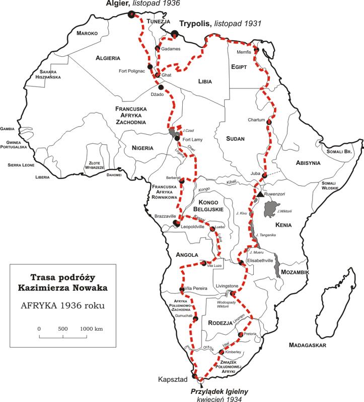
Reminds me history of Kazik Nowak [0], who traveled alone on a bike through Africa. The expedition took him 5 years (between 1931-1936).
He wrote a great book about his trip, prizing amazing African nature and giving a hard time colonial powers for making this continent such a miserable living place for its natives. Book does not have English translation unfortunately.
Nowak died soon after coming back (trip was really exhausting, he got Malaria) and for many years his achievement was forgotten. In 1962 his daughter managed to publish a book her father trip, but it didn't attract much attention (communists didn't like to promote anything positive about pre-communism times achievements). Finally it was reedited in 2000 and become very popular in Poland.
galfarragem
Tangent: take a look on "Another day of life" from Ryszard Kapuscinski. Most unbiased look at Angola decolonization (and decolonization in general) I know.
edit: Ryszard Kapuscinski[0] style, a mix of journalism with literature, definitely worths a read. I believe his legacy is underrated even in his own country.
[0] https://en.wikipedia.org/wiki/Ryszard_Kapu%C5%9Bci%C5%84ski
keiferski
Here's a map of his journey, which is buried on that page:
pxtail
> Book does not have English translation unfortunately.
It looks like there actually is English translation: https://sorus.pl/produkt/across-the-dark-continent-bicycle-d...
tosser0001
It also reminds me of Tschiffely who spent 3 years riding on horseback from Buenos Aires to New York City in the mid-1920s:
https://en.wikipedia.org/wiki/Aim%C3%A9_F%C3%A9lix_Tschiffel...
psychstudio
Title should read "Bloke walked around Australia - alone and with no assistance"
DyslexicAtheist
the first Bogan to ever walk around all Australia just so he could shout "get f******ed" to as many inhabitants as possible.
basementcat
Made me think of Wowbagger the Infinitely Prolonged.
progre
A little more meat in the wikipedia article https://en.wikipedia.org/wiki/Aidan_de_Brune
FreshFries
Title needs something like "between 1921 and 1924".
AbrahamParangi
There’s this funny thing where all these 19th century explorers claim the first ever crossings on foot of this or that area of Australia, a continent that has been inhabited for 70,000 years at least.
DoreenMichele
See also:
Robyn Davidson (born 6 September 1950) is an Australian writer best known for her 1980 book Tracks, about her 2,700 km (1,700 miles) trek across the deserts of Western Australia using camels. Her career of travelling and writing about her travels has spanned 40 years.
js2
That wikipedia page doesn't seem to reference that her book was the basis of a beautiful picture book by National Geographic, From Alice to Ocean, perhaps notable here because the book included a CD-ROM, making it an early attempt at multimedia presentation.
https://www.amazon.com/Alice-Ocean-Alone-Across-Outback/dp/0...
http://macintoshgarden.org/games/alice-ocean
Some reviews of the CD-ROM from a 1994 college class:
http://besser.tsoa.nyu.edu/impact/s94/students/papers.html
(Scroll down to Multimedia Reviews and there four student reviews of the CD.)
akudha
I recommend her book, it was quite enjoyable. There is also a movie, though not as good as the book.
The saddest part of the book is when her dog dies, eating poisoned meat.
Quite a story
satori99
From the headline, I was certain this article was going to be about Jon Muir.
TIL about Aidan de Brune.
leereeves
TIL about Jon Muir. Thank you.
Until I looked it up, I thought you meant John Muir, a famous American naturalist who founded the Sierra Club. It's crazy that there are two famous explorers with such similar names.
hnick
It looks like he ducked inland quite far on the southeast. Really wanted to avoid Canberra I guess :)
More seriously does anyone know why? Just personal preference? My understanding is that it's mostly national parks down there in VIC but I'm not sure how it would be to walk since I've never even driven there. It makes sense to avoid the Snowy Mountains but I think that could have been achieved by swinging around closer to the coast?
74d-fe6-2c6
This reminds me of how equipment required for such an endeavour have been way heavier a hundred years ago. I'm not particuarly experienced with outdoor activities but if I engage in one I have to notice how overloaded and heavy everything is. But most of the stuff is reasonably modern using various lightweight metals or plastics. Realistically people have been stronger back than anyway.
lostlogin
Shackleton ‘South’ is an amazing book on how one can survive on little, with almost no gear and for a long time. It’s truely awesome how they survived and it’s a great book.
laurent92
How do you change shoes after 6 months, when in the middle of the outback?
Gustomaximus
I assume they did with less. No change of clothes. Cook meat on sticks rather than a pan. A blanket and no tent type deal. No medical kit, torch or GPS etc.
silly-silly
I'm not convinced that you'd need a blanket in those areas ;) 40C (104F)+ regularly in summer.
Gustomaximus
Some warmer places drop amazingly at night, more arid regions have reputation for this. Less in tropical. Also even if 18 overnight doesn't seem cold when you're used to 40 by day, anything under 20 seems cold.
Im Brisbane and one time my partner was skyping with her Nordic family. I was getting the fireplace going and they asked the temperature, I cant remember exactly but it was about 20 and any the look on their faces was priceless.
rwmj
Slightly more achievable walk around an island which I intend to do one day: https://en.wikipedia.org/wiki/Shikoku_Pilgrimage It's a mere 1200 km and takes a month or two, rather than two+ years.
Get the top HN stories in your inbox every day.
Crossing the Nullarbor on foot must have been insane. I did the same route but with camping gear and a car in the 90ies, and had the time of my life. The scale of the distances between points on the map are not comprehensible (to a kid from Europe at least). I wanted to do a day trip to Monkey Mia right after getting off the plane and started planning out my journey from Perth. I didn't believe (understand) that there is often nothing between 2 points on the map. A map entry would often just be a literal petrol station (that is also a pub and a shop and a farm) and nothing else. I had to learn the hard way that when they say "there's f*k all there mate" that they really mean it.
I guess the reason for him cutting short the Kimberley's and Northern tip of Queensland, was that it must have been inaccessible or too dangerous back then. Anyway it seems like travelers have already been advised 100 years ago to stay clear of these places.
There is an Ed Stafford "Marooned" episode where he tries to survive in the Kimberley's. (much endorse).
edit: If you have visited Australia (or plan to go) don't miss out on Bill Bryson's "Down Under" (must read if you like travel literature that is also hilarious) https://en.wikipedia.org/wiki/Down_Under_(book)